|
|
What Others have discovered
1. Roman Road over Tihuta (Borgo) Pass
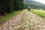
- Objective of Archaeological Tourism, known from the XVIII-th century,
- Features:12km long route, 12m wide, paved, cross section: embankment / excavation
- Area: 850-1150m alt. Meadows / Belvedere
- Route: Bargau Valley - National Road 17 - Prislop hill - Zambroaia hill - Tasuleasa heights - Opcioara heights - Iliuta Corchii - Iliuta Calului - Cailor Hill - DN17 (17th National Road) - Borgo(Tihuta) Pass
- Dated: Roman Age
- Reported / Researched by: Dr. Ioan Baca - lecturer, Faculty of Geography and Tourism, Bistrita Nasaud County
- Access: from DN17, Borgo Pass
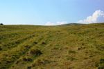
2. Roman Road over Vlahita Pass

- Objective of Archaeological Tourism, known from the XVIII-th century,
- Features: 9km long route, 12m wide, paved, cross section: embankment / mixed
- Area: 550-800m alt. Meadows / Forest
- Route: DN 13A - Bradesti - The left side of "the stone creek" valley - Satu Mare Hill - Homorod resort - Capalna village- DN 13A.
- Dated: Roman Age
- Reported / Researched by: Radu Zagreanu Archaeologist - Eastern Carpathians History Museum
- Access: from DN13A
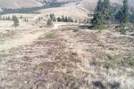
3. Roman Road over Oituz Pass
- Objective of Archaeological Tourism since 2009
- Features: 12km long route, 12m wide, paved, cross section: embankment / excavation
- Area: 600-1200m alt. Meadows / Forest / Belvedere
- Route: DN 11 - Bretcu - Mailat's peak - Boca's Peak - Ghepar Peak - Muntele Mic Peak.
- Dates: Roman Age
- Reported / Researched by: Radu Zagreanu Archaeologist - Eastern Carpathians History Museum, The Archaeologist Dr. Alexandru Popa - Archaeological Institute of Frankfurt, Vlad Totoianu - ARTA Intramuros.
- Access: from DN11, Bretcu village.
4. Roman Road over Tatar's Pass (Tabla Butii)
- Objective of Archaeological Tourism, known from the XVI-th century
- Features:12km long route, 12m wide, paved, cross section: mixed
- Area: 1000-1400m alt. Meadows / Forest / Belvedere
- Route: "The Clearing of The Girl" (Poiana Fetei) - Tatar's Pass - The Tatar's Route - Crai's Peak
- Dates: Roman Age
- Reported / Researched by: Radu Zagreanu Archaeologist - Eastern Carpathians History Museum, Catalin Morar Ranger - Sita Buzaului Forest's Departament, Vlad Totoianu - ARTA Intramuros
- Access: from DJ103A (county road)to Vama Buzaului village and Tatar's Pass (offroad track), or, from the Cerasu village (offroad track)
|